Comments
Membership info
Register new
Login
City:
Home
Reports
Europe Forecast
Topics
UK Forecast
Extra
Forecast
USA
Worldwide
Graphical forecast
UV Index
Water
Weather Search
Expert Charts
Current Weather
Weather
Weather Search
Radar
Satellite
Lightning
Webcams
Tropical Storms
Archive
Graphs
Climate
Graphs
Climate Finder
Travel Planner
Sport
Marine Weather
Tour Weather
Wimbledon
Winter Sports
Lexicon
Weather Facts
Wind of the World
Climate of the World
Weather Brains
Weather Lore
Philip Eden
Oil spill
Fukushima
Volcanic ash
Video
Services
Mobile Weather
B2B
Free Services
Personal Weather
Member
Press Release
Agriculture
Facebook
Google+
Twitter
Visible
Infrared
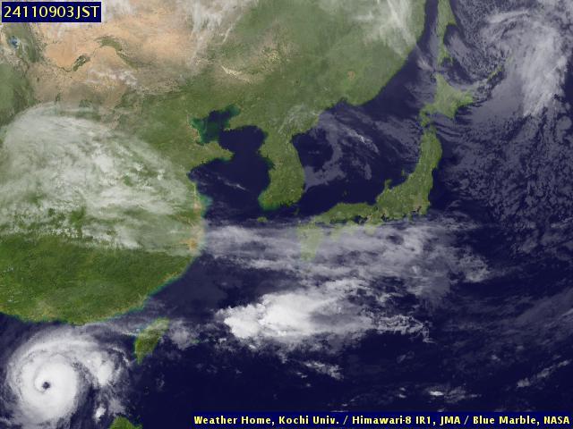
Satellite Image: Japan (IR)
20:00
19:00
18:00
17:00
16:00
15:00
14:00
13:00
12:00
11:00
10:00
09:00
08:00
07:00
06:00
05:00
04:00
03:00
02:00
01:00
00:00
23:00
22:00
21:00
20:00
19:00
18:00
17:00
16:00
15:00
14:00
13:00
12:00
11:00
10:00
09:00
08:00
07:00
06:00
05:00
04:00
03:00
02:00
01:00
00:00
Fri 08 Nov 14:00 EST
Fr
Th
We
Advertisement
Absorbed dose rate
Tokyo
Stations - list
Stations - map
Accumulation - map
Fukushima I Nuclear power plant
ATTENTION: These products are highly uncertain based on limited information for the source terms. Please use with caution and understand that the values are likely to change.
ZAMG: dispersion model
Iodine 131
Xenon 133
Caesium 137
EURAD: dispersion model
Caesium 137 surface
Caesium 137 2500m
Caesium 137 5000m
FLEXPART: dispersion model
Iodine 131
Xenon 133
Caesium 137
HYSPLIT: air parcel trajectories
ensemble
different heights
Summary
IRSN
ZAMG
Current weather
Fukushima
Tokyo
Japan nuclear accident
More information - link list
Maps Japan
Southeast Asia
Streamlines 10m
Streamlines 500 hPa
Japan
Wind 950 hPa
Precipitation
World
Jet stream/Height 300 hPa
Precipitation
Satellite
Visible
Infrared